
Gabelhorngletscher topographic map
Interactive map
Click on the map to display elevation.
About this map
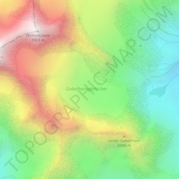
Name: Gabelhorngletscher topographic map, elevation, terrain.
Average elevation: 3,134 m
Minimum elevation: 2,578 m
Maximum elevation: 3,877 m
Other topographic maps
Click on a map to view its topography, its elevation and its terrain.
Pointe Dufour (Mont Rose)
Pointe Dufour (Mont Rose), Zermatt, Viège, Valais, 3920, Suisse
Average elevation: 4,033 m
Gornergrat
Gornergrat, Hohtälli, Ze Seewjinen, Zermatt, Viège, Valais, 3920, Suisse
Average elevation: 2,768 m
Pointe Parrot
Pointe Parrot, Zermatt, Viège, Valais, 3920, Suisse
Average elevation: 3,887 m