
Ham-sur-Sambre topographic map
Interactive map
Click on the map to display elevation.
About this map
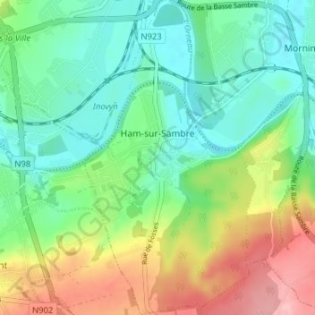
Name: Ham-sur-Sambre topographic map, elevation, terrain.
Location: Ham-sur-Sambre, Jemeppe-sur-Sambre, Namen, Wallonië, België (50.42091 4.65843 50.46174 4.69362)
Average elevation: 129 m
Minimum elevation: 83 m
Maximum elevation: 217 m
Other topographic maps
Click on a map to view its topography, its elevation and its terrain.
Mornimont
België > Wallonië > Jemeppe-sur-Sambre
Mornimont, Jemeppe-sur-Sambre, Namen, Wallonië, België
Average elevation: 121 m