
Mornimont topographic map
Interactive map
Click on the map to display elevation.
About this map
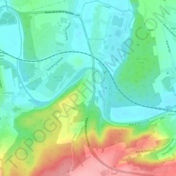
Name: Mornimont topographic map, elevation, terrain.
Location: Mornimont, Jemeppe-sur-Sambre, Namen, Wallonië, België (50.42732 4.68950 50.46353 4.71702)
Average elevation: 121 m
Minimum elevation: 80 m
Maximum elevation: 205 m
Other topographic maps
Click on a map to view its topography, its elevation and its terrain.
Ham-sur-Sambre
België > Wallonië > Jemeppe-sur-Sambre
Ham-sur-Sambre, Jemeppe-sur-Sambre, Namen, Wallonië, België
Average elevation: 129 m