
Wilstead topographic map
Click on the map to display elevation.
About this map
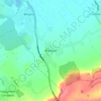
Name: Wilstead topographic map, elevation, terrain.
Location: Wilstead, Bedford, England, MK45 3HD, United Kingdom (52.05949 -0.46847 52.09949 -0.42847)
Average elevation: 45 m
Minimum elevation: 27 m
Maximum elevation: 97 m
Other topographic maps
Click on a map to view its topography, its elevation and its terrain.
Wymington
United Kingdom > England > Bedford
During the Second World War, families in and near Wymington took in children evacuated from urban areas in response to bombing raids, as was typical of many rural towns and villages. In August, 1944 a damaged United States Army Air Forces B-17 "Miss Liberty Belle" based at nearby RAF Chelveston crashed in the…
Average elevation: 86 m