
Make a donation
Nuevo León topographic map
Click on the map to display elevation.
Make a donation
Nuevo León
Nuevo León's geography is known for englobing three of the most important physiographic provinces of the northeast region. The south end of the Great Plains is considered to start in the northernmost regions of Nuevo León. The region is characterized by the soft hills that dominates the lands neighboring the banks of the Rio Grande. The south and west of the state consists of the Sierra Madre Oriental mountain range, which dominates most of the western scenery. Due to the abrupt shape of the mountains, there are vast valleys in between the mountains. Within these valleys is where the city of Monterrey and its metropolitan area is situated. The Northern Gulf Coastal Plains are located to the east and include low altitude lands; it is classified as an "inclined plain" due to the alluvial land.
Make a donation
About this map
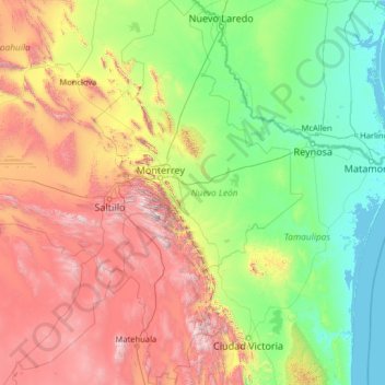
Name: Nuevo León topographic map, elevation, terrain.
Location: Nuevo León, Mexico (23.16267 -101.20676 27.79914 -98.42158)
Average elevation: 805 m
Minimum elevation: -2 m
Maximum elevation: 3,623 m
Make a donation
Other topographic maps
Click on a map to view its topography, its elevation and its terrain.
Make a donation
Ciudad Juárez
Due to its location in the Chihuahuan Desert and high altitude, Ciudad Juárez has a cold desert climate (Köppen: BWk). Seasons are distinct, with hot summers, mild springs and autumns, and cold winters. Summer average high is 35 °C (95 °F) with lows of 21 °C (70 °F). Winter highs average 14 °C (57 °F)…
Average elevation: 1,228 m
Make a donation
Make a donation
Acapulco
Mexico > Guerrero > Acapulco de Juárez
The city, located on the Pacific coast of Mexico in the state of Guerrero, is classified as one of the state's seven regions, dividing the rest of the Guerrero coast into the Costa Grande and the Costa Chica. Forty percent of the municipality is mountainous terrain; another forty percent is semi-flat; and the…
Average elevation: 99 m
Make a donation
Villahermosa
Villahermosa is located in the southeast of Mexico between the rivers Grijalva and Carrizal. The average elevation of the city is 10 meters above sea level. The city also has several lagoons, the largest and most important of them being La Laguna de las Ilusiones (Illusions Lagoon).
Average elevation: 9 m
Make a donation
Make a donation