
Soufriere topographic map
Interactive map
Click on the map to display elevation.
About this map
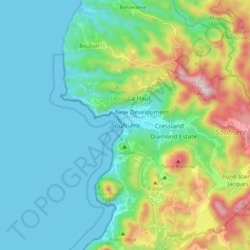
Name: Soufriere topographic map, elevation, terrain.
Location: Soufriere, ST. LUCIA, Saint Lucia (13.81411 -61.09859 13.89411 -61.01859)
Average elevation: 188 m
Minimum elevation: 0 m
Maximum elevation: 703 m
Other topographic maps
Click on a map to view its topography, its elevation and its terrain.
Soufrière Beach
Saint Lucia > Soufriere > Soufriere
Soufrière Beach, Cemetery Street, Soufriere Estate, Fond Bernier, Soufriere, ST. LUCIA, Saint Lucia
Average elevation: 101 m