
Thank you for supporting this site ❤️
Make a donation
Make a donation
Lufkin topographic map
Click on the map to display elevation.
Thank you for supporting this site ❤️
Make a donation
Make a donation
Lufkin
The elevation of Lufkin is 139 to 404 ft above mean sea level.
Thank you for supporting this site ❤️
Make a donation
Make a donation
About this map
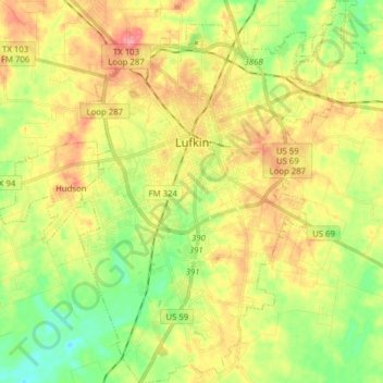
Name: Lufkin topographic map, elevation, terrain.
Location: Lufkin, Angelina County, Texas, United States (31.25458 -94.77505 31.38796 -94.65809)
Average elevation: 88 m
Minimum elevation: 51 m
Maximum elevation: 128 m
Thank you for supporting this site ❤️
Make a donation
Make a donation
Other topographic maps
Click on a map to view its topography, its elevation and its terrain.