
Thank you for supporting this site ❤️
Make a donation
Make a donation
Tann topographic map
Click on the map to display elevation.
Thank you for supporting this site ❤️
Make a donation
Make a donation
About this map
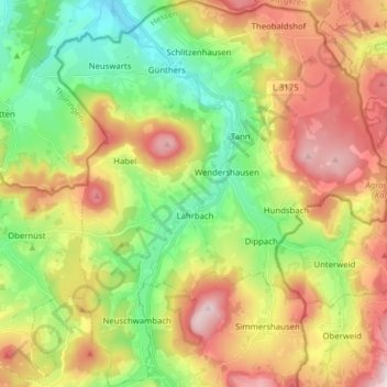
Name: Tann topographic map, elevation, terrain.
Location: Tann, Landkreis Fulda, Hessen, 36142, Duitsland (50.57732 9.94771 50.67647 10.08294)
Average elevation: 504 m
Minimum elevation: 313 m
Maximum elevation: 755 m
Thank you for supporting this site ❤️
Make a donation
Make a donation
Other topographic maps
Click on a map to view its topography, its elevation and its terrain.