
Thank you for supporting this site ❤️
Make a donation
Make a donation
Rothemann topographic map
Click on the map to display elevation.
Thank you for supporting this site ❤️
Make a donation
Make a donation
About this map
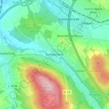
Name: Rothemann topographic map, elevation, terrain.
Location: Rothemann, Eichenzell, Landkreis Fulda, Hessen, 36124, Duitsland (50.44729 9.68331 50.48729 9.72331)
Average elevation: 338 m
Minimum elevation: 271 m
Maximum elevation: 491 m
Thank you for supporting this site ❤️
Make a donation
Make a donation