
Make a donation
San Teodoro topographic map
Click on the map to display elevation.
Make a donation
San Teodoro
Lt. Hutchins saw that the topographic location of Subaan proper was not suitable for future municipal site expansion. The place was surrounded by nipa swamps and marshland, and the shores were muddy and rocky. He asked Pres. Juan Rojas if they could find a broader place for the town site. The president together with the inhabitants led the Americans to the North crossing Subaan River. After about a kilometer walk, the commander was delighted to see the broad, level land facing Subaan Bay with the hills of Balucanag at the rear and the flat land extending up to the banks of Subaan River.
Make a donation
About this map
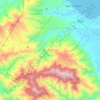
Name: San Teodoro topographic map, elevation, terrain.
Location: San Teodoro, Oriental Mindoro, Mimaropa, 5202, Philippines (13.19735 120.83837 13.45164 121.08020)
Average elevation: 578 m
Minimum elevation: -1 m
Maximum elevation: 2,553 m
Make a donation
Other topographic maps
Click on a map to view its topography, its elevation and its terrain.
Mount Halcon
Philippines > Oriental Mindoro
Mount Halcon (Filipino: Bundok Halcon) and (Spanish: Monte Halcón) is the highest mountain in Mindoro. According to the new data released by Oriental Mindoro peakvisor as of 2022, it has an elevation of 2,616 metres (8,583 ft) above sea level, higher than the previous estimates of 2,586 m (8,484 ft) although…
Average elevation: 2,121 m
Calapan
Philippines > Oriental Mindoro
The overall land characteristic is a wide plain with rivers, interspersed with wetlands at the seacoast periphery. The highest elevation is 187 m (614 ft) above sea level at Bulusan Hill, a 6-kilometre (3.7 mi) long landform east of the city, which interrupts the mostly flat terrain north-east of the…
Average elevation: 40 m
Make a donation
Make a donation
Make a donation
Make a donation
Make a donation
Baco
Philippines > Oriental Mindoro
Majority of the barangays of the municipality are in lowland areas or below 500 meters above sea level (MASL) and cover 41.88 percent of the total land area (13,035.58 ha). The three largest barangays, which cover most of the forestland, have an elevation that ranges from 500-1,000 and greater than 1,000…
Average elevation: 14 m
Make a donation
Make a donation
Roxas
Philippines > Oriental Mindoro
The municipal center of Roxas is situated at approximately 12° 35' North, 121° 31' East, in the island of Mindoro. Elevation at these coordinates is estimated at 10.5 meters (34 ft) above mean sea level.
Average elevation: 7 m
Make a donation
Make a donation
Make a donation
Make a donation
Make a donation
Make a donation
Make a donation
Make a donation
Make a donation
Make a donation
Make a donation
Make a donation
Make a donation
Make a donation
Make a donation
Baco
Philippines > Oriental Mindoro
Majority of the barangays of the municipality are in lowland areas or below 500 meters above sea level (MASL) and cover 41.88 percent of the total land area (13,035.58 ha). The three largest barangays, which cover most of the forestland, have an elevation that ranges from 500-1,000 and greater than 1,000…
Average elevation: 14 m
Make a donation
Make a donation
Make a donation