
Thank you for supporting this site ❤️
Make a donation
Make a donation
Marion County topographic map
Click on the map to display elevation.
Thank you for supporting this site ❤️
Make a donation
Make a donation
Marion County
Marion County is generally composed of rolling hills, much like most of the rest of Florida. The highest elevation is about 60 meters (200 feet). The majority of its trees consist of live oaks, pines, and palm trees.
Thank you for supporting this site ❤️
Make a donation
Make a donation
About this map
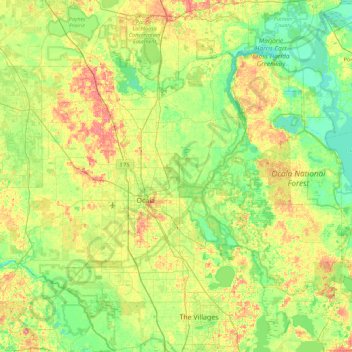
Name: Marion County topographic map, elevation, terrain.
Location: Marion County, Florida, United States (28.95980 -82.53595 29.52168 -81.63893)
Average elevation: 24 m
Minimum elevation: 0 m
Maximum elevation: 70 m
Thank you for supporting this site ❤️
Make a donation
Make a donation
Other topographic maps
Click on a map to view its topography, its elevation and its terrain.
Thank you for supporting this site ❤️
Make a donation
Make a donation
Thank you for supporting this site ❤️
Make a donation
Make a donation
Thank you for supporting this site ❤️
Make a donation
Make a donation
Miami Canal
United States > Florida > Miami-Dade County > Miami > Fronton Trailer Park
Average elevation: 7 m
Thank you for supporting this site ❤️
Make a donation
Make a donation
Legion Park
United States > Florida > Miami-Dade County > Miami > Edison Center
Average elevation: 9 m