
Silenen topographic map
Interactive map
Click on the map to display elevation.
About this map
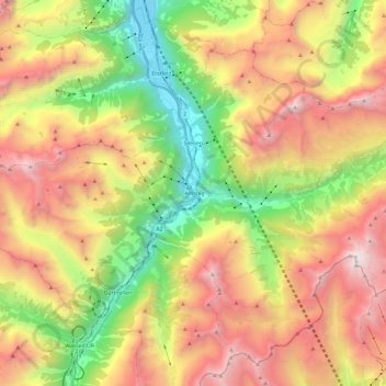
Name: Silenen topographic map, elevation, terrain.
Location: Silenen, Uri, Zwitserland (46.69896 8.64459 46.84297 8.88164)
Average elevation: 1,798 m
Minimum elevation: 452 m
Maximum elevation: 3,309 m
Other topographic maps
Click on a map to view its topography, its elevation and its terrain.
Bristen
Zwitserland > Uri > Gurtnellen
Bristen, Gurtnellen, Uri, 6476, Zwitserland
Average elevation: 2,293 m
Andermatt
Zwitserland > Uri > Korporation Ursern > Andermatt
Andermatt, Korporation Ursern, Uri, 6490, Zwitserland
Average elevation: 2,127 m