
Town of Pawling topographic map
Interactive map
Click on the map to display elevation.
About this map
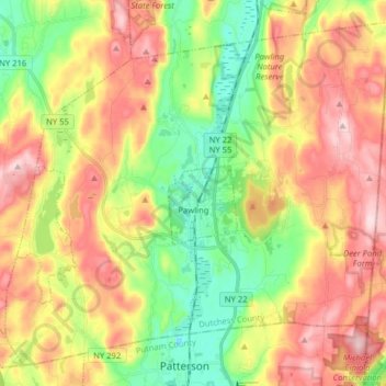
Name: Town of Pawling topographic map, elevation, terrain.
Location: Town of Pawling, Dutchess County, New York, United States (41.51400 -73.68023 41.61979 -73.52144)
Average elevation: 243 m
Minimum elevation: 104 m
Maximum elevation: 400 m
The eastern and western section of the towns are high and hilly, with the Great Swamp and Harlem Valley in the middle, where the village of Pawling is located. The highest elevation in town is Observatory Hill, at 1,332 feet (406 m) above sea level; the lowest is 420 feet (130 m), in the Great Swamp, along the southern boundary of the town.
Other topographic maps
Click on a map to view its topography, its elevation and its terrain.
Town of Amenia
United States > New York > Dutchess County
Town of Amenia, Dutchess County, New York, United States
Average elevation: 256 m
Town of Union Vale
United States > New York > Dutchess County
Town of Union Vale, Dutchess County, New York, 12585, United States
Average elevation: 227 m