
Town of Union Vale topographic map
Interactive map
Click on the map to display elevation.
About this map
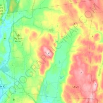
Name: Town of Union Vale topographic map, elevation, terrain.
Average elevation: 227 m
Minimum elevation: 101 m
Maximum elevation: 419 m
Other topographic maps
Click on a map to view its topography, its elevation and its terrain.
Town of Pawling
United States > New York > Dutchess County
Town of Pawling, Dutchess County, New York, United States
Average elevation: 243 m
Town of Amenia
United States > New York > Dutchess County
Town of Amenia, Dutchess County, New York, United States
Average elevation: 256 m