
Wareham topographic map
Interactive map
Click on the map to display elevation.
About this map
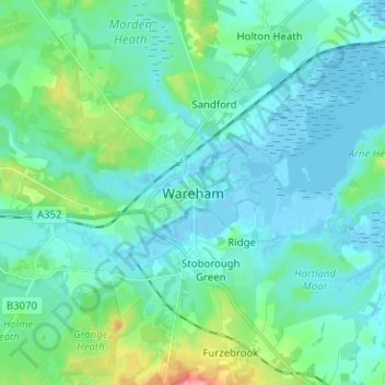
Name: Wareham topographic map, elevation, terrain.
Location: Wareham, Dorset, Inglaterra, BH20 4HU, Reino Unido (50.64690 -2.14984 50.72690 -2.06984)
Average elevation: 16 m
Minimum elevation: -4 m
Maximum elevation: 92 m
Other topographic maps
Click on a map to view its topography, its elevation and its terrain.
Almer
Reino Unido > Inglaterra > Dorset
Almer, Sturminster Marshall, Dorset, Inglaterra, DT11 9EP, Reino Unido
Average elevation: 51 m