
Thank you for supporting this site ❤️
Make a donation
Make a donation
Smiley topographic map
Click on the map to display elevation.
Thank you for supporting this site ❤️
Make a donation
Make a donation
About this map
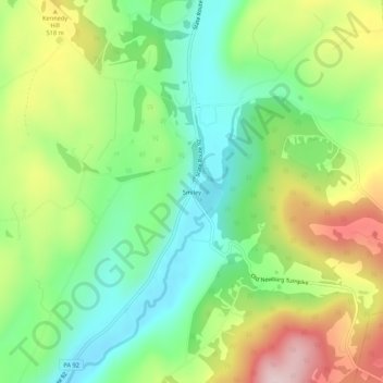
Name: Smiley topographic map, elevation, terrain.
Average elevation: 440 m
Minimum elevation: 303 m
Maximum elevation: 656 m
Thank you for supporting this site ❤️
Make a donation
Make a donation
Other topographic maps
Click on a map to view its topography, its elevation and its terrain.
Thank you for supporting this site ❤️
Make a donation
Make a donation
Thank you for supporting this site ❤️
Make a donation
Make a donation
Thank you for supporting this site ❤️
Make a donation
Make a donation
Fiddle Lake
United States > Pennsylvania > Susquehanna County > Ararat Township
Average elevation: 609 m
Thank you for supporting this site ❤️
Make a donation
Make a donation