
Make a donation
Thompson topographic map
Click on the map to display elevation.
Make a donation
About this map
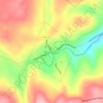
Name: Thompson topographic map, elevation, terrain.
Location: Thompson, Susquehanna County, Pennsylvania, United States (41.85594 -75.52243 41.87184 -75.50577)
Average elevation: 542 m
Minimum elevation: 447 m
Maximum elevation: 614 m
Make a donation
Other topographic maps
Click on a map to view its topography, its elevation and its terrain.
Brackney
United States > Pennsylvania > Susquehanna County > Silver Lake Township
Average elevation: 491 m
Stevens Point
United States > Pennsylvania > Susquehanna County > Harmony Township
Average elevation: 434 m
Woodhouse
United States > Pennsylvania > Susquehanna County > Dimock Township
Average elevation: 416 m
Make a donation
Lakeside
United States > Pennsylvania > Susquehanna County > New Milford Township
Average elevation: 478 m
Elkdale
United States > Pennsylvania > Susquehanna County > Clifford Township
Average elevation: 463 m
Fiddle Lake
United States > Pennsylvania > Susquehanna County > Ararat Township
Average elevation: 609 m
Springville
United States > Pennsylvania > Susquehanna County > Springville Township
Average elevation: 389 m
Make a donation
Make a donation
Make a donation
Smokey Mountain
United States > Pennsylvania > Susquehanna County > Great Bend Township
Average elevation: 359 m