Guadeloupe topographic map
Click on the map to display elevation.
Guadeloupe
The two main islands are Basse-Terre (west) and Grande-Terre (east), which form a butterfly shape as viewed from above, the two 'wings' of which are separated by the Grand Cul-de-Sac Marin, Rivière Salée [fr] and Petit Cul-de-Sac Marin. More than half of Guadeloupe's land surface consists of the 847.8 km2 Basse-Terre. The island is mountainous, containing such peaks as Mount Sans Toucher (4,442 feet; 1,354 metres) and Grande Découverte (4,143 feet; 1,263 metres), culminating in the active volcano La Grande Soufrière, the highest mountain peak in the Lesser Antilles with an elevation of 1,467 metres (4,813 ft). In contrast Grande-Terre is mostly flat, with rocky coasts to the north, irregular hills at the centre, mangrove at the southwest, and white sand beaches sheltered by coral reefs along the southern shore. This is where the main tourist resorts are found.
About this map
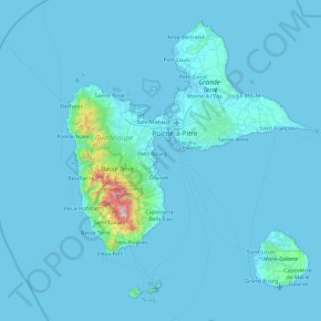
Name: Guadeloupe topographic map, elevation, terrain.
Location: Guadeloupe, France (15.83198 -61.80976 16.51448 -61.00130)
Average elevation: 37 m
Minimum elevation: -1 m
Maximum elevation: 1,442 m
Other topographic maps
Click on a map to view its topography, its elevation and its terrain.
Angers
France > Pays de la Loire > Maine-et-Loire > Angers
Elevation varies 12 to 64 meters (39 to 210 ft) above sea level.
Average elevation: 44 m

Raphèle-lès-Arles
France > Provence-Alpes-Côte d'Azur > Bouches-du-Rhône > Arles
Average elevation: 13 m

Les Huguets
France > Auvergne-Rhône-Alpes > Ain > Saint-Didier-sur-Chalaronne
Average elevation: 184 m
Avignon
France > Provence-Alpes-Côte d'Azur > Vaucluse > Avignon
Enclosed by the city walls, the Rocher des Doms is a limestone elevation of Urgonian type, 35 metres high (and therefore safe from flooding of the Rhone which it overlooks) and is the original core of the city. Several limestone massifs are present around the commune (the Massif des Angles,…
Average elevation: 58 m
La Basse Gambrie
France > Brittany > Ille-et-Vilaine > La Chapelle-Fleurigné > Fleurigné
Average elevation: 180 m
La Brutz
France > Pays de la Loire > Loire-Atlantique > Rougé > La Grée Pothin
Average elevation: 65 m
Colombis
France > Provence-Alpes-Côte d'Azur > Vaucluse > Châteauneuf-du-Pape > La Croze
Average elevation: 58 m


La Petite Cour Batonnerie
France > Bourgogne-Franche-Comté > Yonne > Toucy > La Mine d'Or
Average elevation: 257 m


Le Grand Meslier
France > Normandy > Manche > Carentan-les-Marais > Houesville
Average elevation: 15 m

Pointe du Villonet
France > Auvergne-Rhône-Alpes > Savoy > Saint-Colomban-des-Villards
Average elevation: 2,256 m

Le Bois Chapeleau
France > Nouvelle-Aquitaine > Deux-Sèvres > Beugnon-Thireuil
Average elevation: 120 m




Éboulement de Vérel
France > Auvergne-Rhône-Alpes > Savoy > Verel-Pragondran > Vérel > Les Chavannes
Average elevation: 753 m

Le Cotel
France > Auvergne-Rhône-Alpes > Isère > Autrans-Méaudre en Vercors > Méaudre
Average elevation: 1,108 m
La mare aux éléphants
France > French Southern and Antarctic Lands > Martin-de-Viviès
Average elevation: 40 m




Peyredeyre
France > Auvergne-Rhône-Alpes > Haute-Loire > Chaspinhac > Peyredeyre
Average elevation: 739 m
Canal de Fumemorte
France > Provence-Alpes-Côte d'Azur > Bouches-du-Rhône > Arles
Average elevation: 0 m

Langély
France > Nouvelle-Aquitaine > Corrèze > Arnac-Pompadour > Le Queyraud Haut
Average elevation: 346 m


La Quenouillère
France > Pays de la Loire > Maine-et-Loire > Brain-sur-Longuenée
Average elevation: 68 m
Beaumont du Ventoux
France > Provence-Alpes-Côte d'Azur > Vaucluse > Beaumont-du-Ventoux > Beaumont du Ventoux
Average elevation: 501 m
Le Pied du Col
France > Provence-Alpes-Côte d'Azur > Hautes-Alpes > Villar-d'Arêne > Le Pied du Col
Average elevation: 2,101 m

Piton de la Viaclose
France > Provence-Alpes-Côte d'Azur > Hautes-Alpes > La Chapelle-en-Valgaudémar
Average elevation: 2,607 m