
Thank you for supporting this site ❤️
Make a donation
Make a donation
Hell Bourg topographic map
Click on the map to display elevation.
Thank you for supporting this site ❤️
Make a donation
Make a donation
About this map
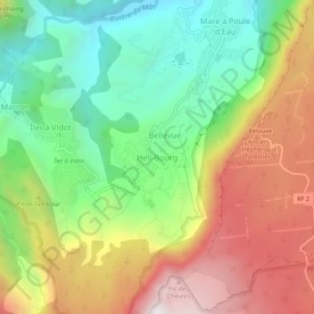
Name: Hell Bourg topographic map, elevation, terrain.
Location: Hell-Bourg, Hell Bourg, Saint-Benoît, Réunion, 97433, France (-21.08420 55.50226 -21.04420 55.54226)
Average elevation: 1,132 m
Minimum elevation: 538 m
Maximum elevation: 1,905 m
Thank you for supporting this site ❤️
Make a donation
Make a donation