
Jimena de la Frontera topographic map
Interactive map
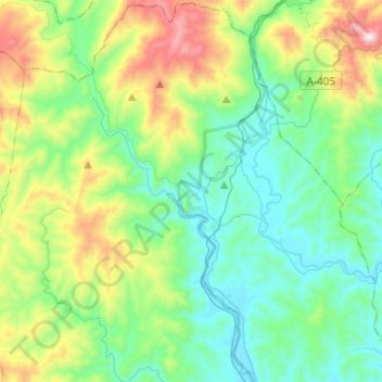
Click on the map to display elevation.
About this map
Name: Jimena de la Frontera topographic map, elevation, terrain.
Average elevation: 269 m
Minimum elevation: 14 m
Maximum elevation: 1,001 m
Jimena de la Frontera enjoys a moderate Mediterranean climate. There are 3,000 hours of sunshine per year, which contributes to average temperatures of between 18 and 20 °C (64 and 68 °F). However, the rainfall pattern differs significantly from the rest of southern Spain, due to the topography of the Strait of Gibraltar region, which is swept by east and west winds that bring humidity and, therefore, rainfall averaging 900 to 1,000 mm (35 to 39 in).
Other topographic maps
Click on a map to view its topography, its elevation and its terrain.
Los Barrios
Spain > Andalusia > Campo de Gibraltar
Los Barrios, Campo de Gibraltar, Cádiz, Andalusia, Spain
Average elevation: 164 m
Campo de Gibraltar
Spain > Andalusia > Campo de Gibraltar
Campo de Gibraltar, Cádiz, Andalusia, Spain
Average elevation: 149 m