
Thank you for supporting this site ❤️
Make a donation
Make a donation
Campo de Gibraltar topographic map
Click on the map to display elevation.
Thank you for supporting this site ❤️
Make a donation
Make a donation
About this map
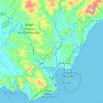
Name: Campo de Gibraltar topographic map, elevation, terrain.
Location: Campo de Gibraltar, Cádiz, Andalusia, Spain (36.00004 -5.84219 36.53778 -5.25237)
Average elevation: 149 m
Minimum elevation: -3 m
Maximum elevation: 1,427 m
Thank you for supporting this site ❤️
Make a donation
Make a donation
Other topographic maps
Click on a map to view its topography, its elevation and its terrain.
Santa Margarita
Spain > Andalusia > Campo de Gibraltar > La Línea de la Concepción
Average elevation: 63 m