
Make a donation
Limpopo topographic map
Click on the map to display elevation.
Make a donation
About this map
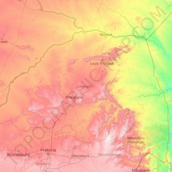
Name: Limpopo topographic map, elevation, terrain.
Location: Limpopo, South Africa (-25.42284 26.40754 -22.12503 31.88439)
Average elevation: 887 m
Minimum elevation: 107 m
Maximum elevation: 2,306 m
Make a donation
Other topographic maps
Click on a map to view its topography, its elevation and its terrain.
Cathkin Park
South Africa > Western Cape > City of Cape Town > Mitchells Plain
Average elevation: 15 m
Clarens
South Africa > Free State > Thabo Mofutsanyana District Municipality > Dihlabeng Local Municipality
Average elevation: 1,874 m
Hekpoort
South Africa > Gauteng > West Rand District Municipality > Mogale City Local Municipality
Average elevation: 1,278 m
Make a donation
Evander
South Africa > Mpumalanga > Gert Sibande > Govan Mbeki Local Municipality
Average elevation: 1,628 m
Gqeberha
South Africa > Eastern Cape > Nelson Mandela Bay Metropolitan Municipality
Average elevation: 37 m
Lekkersing
South Africa > Northern Cape > Namakwa District Municipality > Richtersveld Local Municipality
Average elevation: 389 m
Elim
South Africa > Western Cape > Overberg District Municipality > Cape Agulhas Local Municipality
Average elevation: 60 m
Make a donation
Kwamathukuza
South Africa > KwaZulu-Natal > Amajuba District Municipality > Newcastle Local Municipality
Average elevation: 1,199 m
Winburg
South Africa > Free State > Lejweleputswa District Municipality > Masilonyana Local Municipality
Average elevation: 1,449 m
Beaufort West
South Africa > Western Cape > Central Karoo District Municipality > Beaufort West Local Municipality
Average elevation: 854 m
Make a donation
City of Johannesburg Metropolitan Municipality
South Africa > Gauteng > City of Johannesburg Metropolitan Municipality
Average elevation: 1,615 m
Coligny
South Africa > North West > Ngaka Modiri Molema District Municipality > Ditsobotla Local Municipality
Average elevation: 1,477 m
Napier
South Africa > Western Cape > Overberg District Municipality > Cape Agulhas Local Municipality
Average elevation: 170 m
Make a donation
Harold Johnson Nature Reserve
South Africa > KwaZulu-Natal > iLembe District Municipality > Mandeni Local Municipality
Average elevation: 51 m
Mogalakwena
South Africa > Limpopo > Waterberg District Municipality > Mogalakwena Local Municipality
Average elevation: 855 m