
Kontcha topographic map
Interactive map
Click on the map to display elevation.
About this map
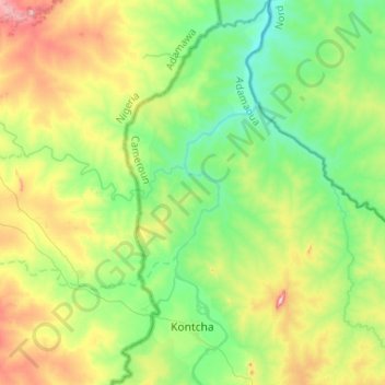
Name: Kontcha topographic map, elevation, terrain.
Location: Kontcha, Faro-et-Déo, Région de l'Adamaoua, Cameroun (7.93502 12.18968 8.19136 12.43069)
Average elevation: 435 m
Minimum elevation: 336 m
Maximum elevation: 642 m
Other topographic maps
Click on a map to view its topography, its elevation and its terrain.
Tignère
Cameroun > Région de l'Adamaoua > Faro-et-Déo
Tignère, Faro-et-Déo, Région de l'Adamaoua, Cameroun
Average elevation: 994 m