
Tignère topographic map
Interactive map
Click on the map to display elevation.
About this map
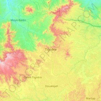
Name: Tignère topographic map, elevation, terrain.
Location: Tignère, Faro-et-Déo, Région de l'Adamaoua, Cameroun (6.96734 12.24170 7.75510 13.24641)
Average elevation: 994 m
Minimum elevation: 425 m
Maximum elevation: 2,380 m
Other topographic maps
Click on a map to view its topography, its elevation and its terrain.
Kontcha
Cameroun > Région de l'Adamaoua > Faro-et-Déo
Kontcha, Faro-et-Déo, Région de l'Adamaoua, Cameroun
Average elevation: 435 m