
Torngat Mountains National Park topographic map
Interactive map
Click on the map to display elevation.
About this map
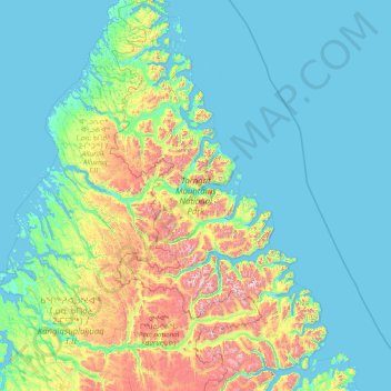
Name: Torngat Mountains National Park topographic map, elevation, terrain.
Average elevation: 214 m
Minimum elevation: -2 m
Maximum elevation: 1,547 m
Other topographic maps
Click on a map to view its topography, its elevation and its terrain.
Corner Brook
Canada > Newfoundland and Labrador
Corner Brook, Newfoundland, Newfoundland and Labrador, Canada
Average elevation: 236 m
Pass Island
Canada > Newfoundland and Labrador
Pass Island, Newfoundland, Newfoundland and Labrador, Canada
Average elevation: 56 m
Smith Sound Provincial Park
Canada > Newfoundland and Labrador
Smith Sound Provincial Park, Newfoundland and Labrador, Canada
Average elevation: 19 m
Fortune
Canada > Newfoundland and Labrador > Fortune
Fortune, Newfoundland and Labrador, A0E 1P0, Canada
Average elevation: 86 m
Labrador
Canada > Newfoundland and Labrador
Labrador, Newfoundland and Labrador, Canada
Average elevation: 227 m
Long Range Mountains
Canada > Newfoundland and Labrador
Long Range Mountains, Newfoundland and Labrador, Canada
Average elevation: 557 m
Maria Island
Canada > Newfoundland and Labrador
Maria Island, Newfoundland and Labrador, Canada
Average elevation: 41 m