
Mount Dandenong topographic map
Interactive map
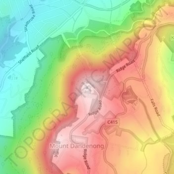
Click on the map to display elevation.
About this map
Name: Mount Dandenong topographic map, elevation, terrain.
Average elevation: 413 m
Minimum elevation: 163 m
Maximum elevation: 621 m
Mount Dandenong has an oceanic climate (Cfb) with warm summers and cool winters. The temperature usually is 3 - 7 °C (5.4 - 12.6 °F) cooler than downtown Melbourne due to its elevation and distance from the urban island heating effect of Melbourne.
Other topographic maps
Click on a map to view its topography, its elevation and its terrain.
Science Garden
Australia > Victoria > Melbourne
Science Garden, Greenvale, Melbourne, City of Hume, Victoria, 3059, Australia
Average elevation: 174 m
Melbourne Water Retarding Basin
Australia > Victoria > Melbourne
Melbourne Water Retarding Basin, Carrum Downs, Melbourne, City of Frankston, Victoria, Australia
Average elevation: 22 m
Doncaster Hill
Australia > Victoria > Melbourne
Doncaster Hill, Melbourne, City of Manningham, Victoria, 3108, Australia
Average elevation: 86 m
City of Greater Geelong
City of Greater Geelong, Victoria, Australia
Average elevation: 77 m
Warrnambool
Australia > Victoria > Warrnambool
Warrnambool, City of Warrnambool, Victoria, 3280, Australia
Average elevation: 19 m
Rural City of Mildura
Rural City of Mildura, Victoria, Australia
Average elevation: 65 m
Wilsons Promontory
Wilsons Promontory, Shire of South Gippsland, Gippsland, Victoria, Australia
Average elevation: 28 m
Wingan River
Wingan River, Shire of East Gippsland, Gippsland, Victoria, Australia
Average elevation: 131 m
Manifold Heights
Australia > Victoria > Geelong
Manifold Heights, Geelong, City of Greater Geelong, Barwon South West, Victoria, 3218, Australia
Average elevation: 41 m
Mount Feathertop
Mount Feathertop, Alpine Shire, Hume, Victoria, Australia
Average elevation: 1,533 m
Hattah - Kulkyne National Park
Australia > Victoria > Colignan
Hattah - Kulkyne National Park, Reed Road, Hattah, Colignan, Rural City of Mildura, Loddon Mallee, Victoria, Australia
Average elevation: 51 m
Wilsons Promontory National Park
Wilsons Promontory National Park, Vereker Outlook, Wilsons Promontory, Shire of South Gippsland, Gippsland, Victoria, Australia
Average elevation: 32 m
Mount Fraser
Mount Fraser, Shire of Mitchell, Hume, Victoria, 3753, Australia
Average elevation: 309 m
Spring Hill
Spring Hill, Shire of Mount Alexander, Loddon Mallee, Victoria, Australia
Average elevation: 421 m
Mount Dawson
Mount Dawson, Shire of East Gippsland, Gippsland, Victoria, Australia
Average elevation: 435 m
Croajingolong National Park
Croajingolong National Park, Lake Barracotta Link Track, Genoa, Shire of East Gippsland, Gippsland, Victoria, Australia
Average elevation: 50 m
Narre Warren
Australia > Victoria > Harkaway
Narre Warren, Harkaway, City of Casey, Victoria, Australia
Average elevation: 42 m
Basalt Lake
Australia > Victoria > Harkaway
Basalt Lake, Board Walk, Berwick, Harkaway, City of Casey, Victoria, 3806, Australia
Average elevation: 76 m
Mount Buangor State Park
Mount Buangor State Park, Saddle Road, Buangor, Shire of Pyrenees, Grampians, Victoria, VIC 3375, Australia
Average elevation: 588 m
Badger Creek
Australia > Victoria > Healesville
Badger Creek, Healesville, Shire of Yarra Ranges, Victoria, Australia
Average elevation: 255 m