
Pulau Dayang Bunting topographic map
Interactive map
Click on the map to display elevation.
About this map
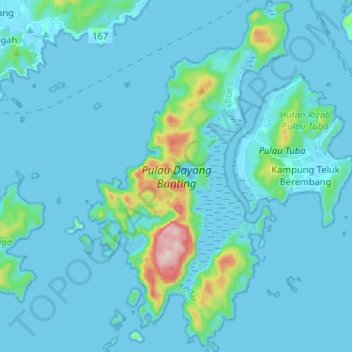
Name: Pulau Dayang Bunting topographic map, elevation, terrain.
Location: Pulau Dayang Bunting, Kedah, Malaysia (6.16785 99.76801 6.29567 99.84290)
Average elevation: 41 m
Minimum elevation: -2 m
Maximum elevation: 465 m
Other topographic maps
Click on a map to view its topography, its elevation and its terrain.