
Rangareddy topographic map
Interactive map
Click on the map to display elevation.
About this map
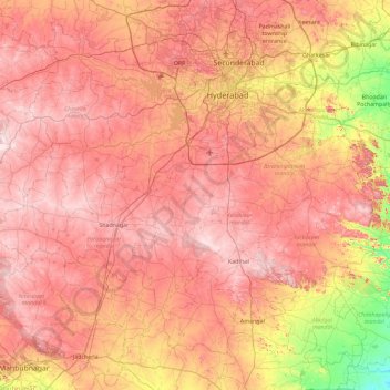
Name: Rangareddy topographic map, elevation, terrain.
Location: Rangareddy, Telangana, Indien (16.74423 77.92191 17.52265 78.84398)
Average elevation: 553 m
Minimum elevation: 314 m
Maximum elevation: 721 m
Other topographic maps
Click on a map to view its topography, its elevation and its terrain.
Shamirpet
Indien > Telangana > Shamirpet mandal
Shamirpet, Shamirpet mandal, Medchal–Malkajgiri District, Telangana, 500078, Indien
Average elevation: 563 m
Chengicherla
Indien > Telangana > Chengicherla
Chengicherla, Medipally mandal, Medchal–Malkajgiri, Telangana, 500092, Indien
Average elevation: 509 m
Prem Nagar
Indien > Telangana > Prem Nagar
Prem Nagar, Mutharam_Mahadevpur mandal, Jayashankar Bhupalapally District, Telangana, Indien
Average elevation: 147 m