
Telangana topographic map
Interactive map
Click on the map to display elevation.
About this map
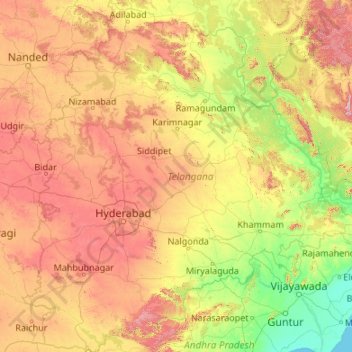
Name: Telangana topographic map, elevation, terrain.
Location: Telangana, Indien (15.83635 77.23659 19.91730 81.32113)
Average elevation: 320 m
Minimum elevation: 0 m
Maximum elevation: 1,262 m
Other topographic maps
Click on a map to view its topography, its elevation and its terrain.
Shamirpet
Indien > Telangana > Shamirpet mandal
Shamirpet, Shamirpet mandal, Medchal–Malkajgiri District, Telangana, 500078, Indien
Average elevation: 563 m
Chengicherla
Indien > Telangana > Chengicherla
Chengicherla, Medipally mandal, Medchal–Malkajgiri, Telangana, 500092, Indien
Average elevation: 509 m
Prem Nagar
Indien > Telangana > Prem Nagar
Prem Nagar, Mutharam_Mahadevpur mandal, Jayashankar Bhupalapally District, Telangana, Indien
Average elevation: 147 m