
Make a donation
Penglai District topographic map
Click on the map to display elevation.
Make a donation
Penglai District
The production of wine is the second largest industry in the province. Agriculture is first. However, in Penglai, tourism is the primary industry, and wine-making is second. The hills south of Penglai have an average elevation of 200 metres (660 ft), while the coastal areas are relatively flat. Most of the soil is loose, well-aerated, and rich in minerals and organic matters that enable full development of the root systems. The wineries are located mainly in the Nanwang Grape Valley and along the Yan-Peng Sightseeing Highway. The main varieties grown there, like Cabernet Sauvignon, Cabernet Gernischt, Merlot, Riesling and Chardonnay, are all reaching 20 years of age, considered to be the golden stage for these grapes. Most of them maintain an average sugar content of above 20%. The Cabernet is especially typical, with good color and a dense fragrance.
Make a donation
About this map
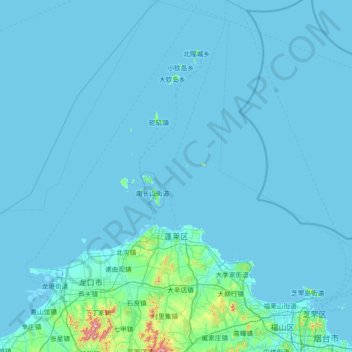
Name: Penglai District topographic map, elevation, terrain.
Location: Penglai District, Yantai, Shandong, 264000, China (37.41537 120.34080 38.55837 121.20853)
Average elevation: 20 m
Minimum elevation: -3 m
Maximum elevation: 742 m
Make a donation
Other topographic maps
Click on a map to view its topography, its elevation and its terrain.
Qingdao
Qingdao is located on the south facing coast of the Shandong Peninsula (German: Schantung Halbinsel). It borders three prefecture-level cities, namely Yantai to the northeast, Weifang to the west, and Rizhao to the southwest. The city's total jurisdiction area occupies 10,654 square kilometres (4,114 sq mi),…
Average elevation: 25 m
Make a donation
Make a donation
Make a donation
Make a donation