
Thank you for supporting this site ❤️
Make a donation
Make a donation
Startzville topographic map
Click on the map to display elevation.
Thank you for supporting this site ❤️
Make a donation
Make a donation
About this map
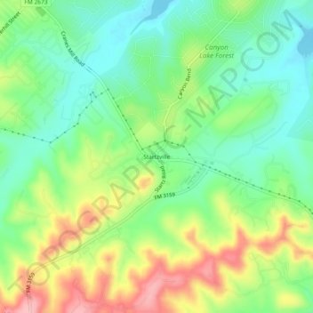
Name: Startzville topographic map, elevation, terrain.
Location: Startzville, Comal County, Texas, 79133, United States (29.82466 -98.29390 29.86466 -98.25390)
Average elevation: 333 m
Minimum elevation: 276 m
Maximum elevation: 426 m
Thank you for supporting this site ❤️
Make a donation
Make a donation
Other topographic maps
Click on a map to view its topography, its elevation and its terrain.
Thank you for supporting this site ❤️
Make a donation
Make a donation
Thank you for supporting this site ❤️
Make a donation
Make a donation
Comal River
United States > Texas > Comal County > New Braunfels > Landa Park Estates
Average elevation: 206 m
Thank you for supporting this site ❤️
Make a donation
Make a donation