
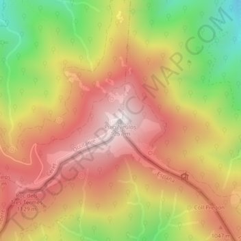
Puig Neulós topographic map
Interactive map
Click on the map to display elevation.
About this map
Name: Puig Neulós topographic map, elevation, terrain.
Average elevation: 895 m
Minimum elevation: 424 m
Maximum elevation: 1,246 m
Der Puig Neulós (französisch Pic du Néoulous) ist mit einer Höhe von 1256 Metern der höchste Berg der Gebirgskette Serra de l’Albera (Französisch: Massif des Albères). Er liegt im Norden von Katalonien und bildet seit dem Pyrenäenfrieden im Jahre 1659 die Grenze zwischen Frankreich und Spanien.
Other topographic maps
Click on a map to view its topography, its elevation and its terrain.
La Vallée Heureuse
Frankreich > Okzitanien > Ostpyrenäen > Sorède
La Vallée Heureuse, Sorède, Céret, Ostpyrenäen, Okzitanien, Metropolitanes Frankreich, 66690, Frankreich
Average elevation: 349 m