
La Vallée Heureuse topographic map
Interactive map
Click on the map to display elevation.
About this map
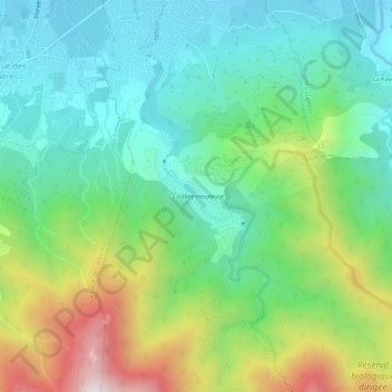
Name: La Vallée Heureuse topographic map, elevation, terrain.
Average elevation: 349 m
Minimum elevation: 71 m
Maximum elevation: 974 m
Other topographic maps
Click on a map to view its topography, its elevation and its terrain.
Puig Neulós
Frankreich > Okzitanien > Ostpyrenäen > Sorède
Puig Neulós, Sorède, Céret, Ostpyrenäen, Okzitanien, Metropolitanes Frankreich, 66690, Frankreich
Average elevation: 895 m