
Make a donation
Oued Smar topographic map
Click on the map to display elevation.
Make a donation
About this map
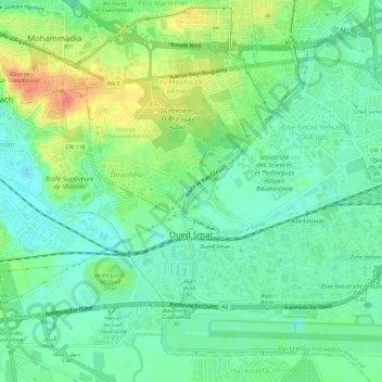
Name: Oued Smar topographic map, elevation, terrain.
Location: Oued Smar, El Harrach District, Algiers, Algeria (36.69509 3.14756 36.72454 3.20680)
Average elevation: 19 m
Minimum elevation: 0 m
Maximum elevation: 54 m
Make a donation
Other topographic maps
Click on a map to view its topography, its elevation and its terrain.
Algiers
Algeria > Algiers > Sidi M'Hamed District
Algiers was a walled city from the time of the deys until the close of the 19th century. The French, after their occupation of the city (1830), built a rampart, parapet and ditch, with two terminal forts, Bab Azoun باب عزون to the south and Bab-el-Oued اد to the north. The forts and part of the…
Average elevation: 45 m
Make a donation
Algiers
Algeria > Algiers > Sidi M'Hamed District
Algiers was a walled city from the time of the deys until the close of the 19th century. The French, after their occupation of the city (1830), built a rampart, parapet and ditch, with two terminal forts, Bab Azoun باب عزون to the south and Bab-el-Oued اد to the north. The forts and part of the…
Average elevation: 45 m
Make a donation
Algiers
Algeria > Algiers > Sidi M'Hamed District
Algiers was a walled city from the time of the deys until the close of the 19th century. The French, after their occupation of the city (1830), built a rampart, parapet and ditch, with two terminal forts, Bab Azoun باب عزون to the south and Bab-el-Oued اد to the north. The forts and part of the…
Average elevation: 45 m
Algiers
Algeria > Algiers > Sidi M'Hamed District > Alger-Centre
The city contains the largest infrastructure facilities in the country; railway and highway connections with neighbouring cities and international links via the Houari Boumediene Airport and Algiers Ferry Terminal. Algiers possesses notable mass transit options, that includes the Algiers Metro, the city's…
Average elevation: 45 m
Make a donation
The subdivision Mandariniers
Algeria > Algiers > Dar el-Beida District > Al Muhammadiyya > Pins Maritimes
Average elevation: 17 m
Bordj el Bahri Faizi
Algeria > Algiers > Dar el-Beida District > Bordj El Bahri
Average elevation: 19 m
Make a donation
The subdivision Mandariniers
Algeria > Algiers > Dar el-Beida District > Al Muhammadiyya > Pins Maritimes
Average elevation: 17 m
Algiers
Algeria > Algiers > Sidi M'Hamed District > Alger-Centre
The city's downtown sits at an elevation of 2 m (at the Algiers Central Post Office), while it averages 45 m across the city's metropolitan area, and tops at 407 m on the Bouzaréah peak. Algiers Province, the administrative area that includes the city's urban and suburban centers covers 1,190 km2 (460 sq mi).
Average elevation: 45 m
Make a donation
Résidence Le Badr
Algeria > Algiers > Dar el-Beida District > Bordj El Bahri > Cité 252 log
Average elevation: 14 m
Algiers
Algeria > Algiers > Sidi M'Hamed District > Alger-Centre
Algiers was a walled city from the time of the deys until the close of the 19th century. The French, after their occupation of the city (1830), built a rampart, parapet and ditch, with two terminal forts, Bab Azoun باب عزون to the south and Bab-el-Oued اد to the north. The forts and part of the…
Average elevation: 45 m
Algiers
Algeria > Algiers > Sidi M'Hamed District
Algiers was a walled city from the time of the deys until the close of the 19th century. The French, after their occupation of the city (1830), built a rampart, parapet and ditch, with two terminal forts, Bab Azoun باب عزون to the south and Bab-el-Oued اد to the north. The forts and part of the…
Average elevation: 45 m
Make a donation
Clos de car
Algeria > Algiers > Dar el-Beida District > Bordj El Bahri > Bordj el Bahri Faizi
Average elevation: 19 m
Algiers
Algeria > Algiers > Sidi M'Hamed District > Alger-Centre
Algiers was a walled city from the time of the deys until the close of the 19th century. The French, after their occupation of the city (1830), built a rampart, parapet and ditch, with two terminal forts, Bab Azoun باب عزون to the south and Bab-el-Oued اد to the north. The forts and part of the…
Average elevation: 45 m
Make a donation
El Madania
Algeria > Algiers > Sidi M'Hamed District > El Madania > El Madania
Average elevation: 90 m
Bab Ezzouar
Algeria > Algiers > Dar El Beida District > Bab Ezzouar > Bab Ezzouar
Average elevation: 15 m
Make a donation
Droudj el Rounda (Rounda Steps)
Algeria > Algiers > Bab El Oued District > Beau Fraisier
Average elevation: 91 m
617 apartment district
Algeria > Algiers > Draria District > Draria > Draria > 617 apartment district
Average elevation: 197 m
Make a donation
Gué de Constantine
Algeria > Algiers > Bir Mourad Rais District > Gué de Constantine
Average elevation: 48 m
El Magharia
Algeria > Algiers > Hussein Dey District > El Magharia > El Magharia
Average elevation: 30 m
Make a donation