
Rayagada topographic map
Interactive map
Click on the map to display elevation.
About this map
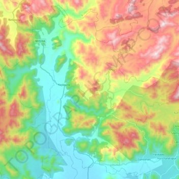
Name: Rayagada topographic map, elevation, terrain.
Location: Rayagada, Gajapati, Odisha, 761213, India (18.85886 84.07322 19.07262 84.31187)
Average elevation: 479 m
Minimum elevation: 71 m
Maximum elevation: 1,139 m
Other topographic maps
Click on a map to view its topography, its elevation and its terrain.
Bhubaneshwar
India > Odisha > Bhubaneswar (M.Corp.)
Bhubaneshwar, Bhubaneswar Municipal Corporation, Bhubaneswar (M.Corp.), Khordha District, Odisha, 751001, India
Average elevation: 30 m