
Eastern Ghats topographic map
Interactive map
Click on the map to display elevation.
About this map
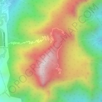
Name: Eastern Ghats topographic map, elevation, terrain.
Location: Eastern Ghats, Gajapati, Odisha, India (18.97015 84.36691 18.97025 84.36701)
Average elevation: 1,130 m
Minimum elevation: 777 m
Maximum elevation: 1,494 m
Other topographic maps
Click on a map to view its topography, its elevation and its terrain.
Bhubaneshwar
India > Odisha > Bhubaneswar (M.Corp.)
Bhubaneshwar, Bhubaneswar Municipal Corporation, Bhubaneswar (M.Corp.), Khordha District, Odisha, 751001, India
Average elevation: 30 m