
Thank you for supporting this site ❤️
Make a donation
Make a donation
Twinsburg topographic map
Click on the map to display elevation.
Thank you for supporting this site ❤️
Make a donation
Make a donation
About this map
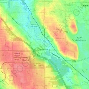
Name: Twinsburg topographic map, elevation, terrain.
Location: Twinsburg, Summit County, Ohio, 44087, United States (41.28267 -81.48917 41.34978 -81.39901)
Average elevation: 321 m
Minimum elevation: 285 m
Maximum elevation: 361 m
Thank you for supporting this site ❤️
Make a donation
Make a donation
Other topographic maps
Click on a map to view its topography, its elevation and its terrain.
Thank you for supporting this site ❤️
Make a donation
Make a donation
Thank you for supporting this site ❤️
Make a donation
Make a donation