
Make a donation
Yalova topographic map
Click on the map to display elevation.
Make a donation
About this map
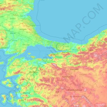
Name: Yalova topographic map, elevation, terrain.
Location: Yalova, Marmara Region, Turkey (37.97954 26.56870 43.17954 31.76870)
Average elevation: 404 m
Minimum elevation: -2 m
Maximum elevation: 2,703 m
Make a donation
Other topographic maps
Click on a map to view its topography, its elevation and its terrain.
Oludeniz
Ölüdeniz offer a variety of diving opportunities with regard to its crystal clear waters and rich underwater caves and fauna. Scuba diving is the most popular underwater activity. Local diving agencies provide courses and required scuba diving licences. Snorkelling is another diving activity and many sites…
Average elevation: 541 m
Make a donation
Make a donation
Make a donation
Make a donation
Antakya
Antakya's climate is classified as hot-summer Mediterranean (Köppen: Csa) or dry-summer humid subtropical (Trewartha: Cf or wet Cs). The city experiences hot, dry summers, and mild, wet winters; though its higher altitude allows for lower temperatures than the coast.
Average elevation: 385 m
Taurus Mountains
The mountains have a Mediterranean climate, with dry summers and rainy winters. Temperatures vary with elevation, with warm winters on the lower coastal slopes and cold winters in the high mountains and in the interior.
Average elevation: 828 m
Make a donation
Antalya
The highest point of the Taurus mountains is Akdağ at an altitude of 3025 metres. Located to the northwest of the city centre and at a distance of 50 km (31 mi) is the Saklıkent ski and recreation centre on Beydağları. Here one can ski and then go down to the shore and into the sea during the months of…
Average elevation: 644 m
Make a donation
Sivas
The city, which lies at an elevation of 1,278 metres (4,193 ft) in the broad valley of the Kızılırmak river, is a moderately-sized trade centre and industrial city, although the economy has traditionally been based on agriculture. Rail repair shops and a thriving manufacturing industry of rugs, bricks,…
Average elevation: 1,482 m
Make a donation
Make a donation
Lake Van
Lake Van (Turkish: Van Gölü; Armenian: Վանա լիճ, romanized: Vana lič̣; Kurdish: Gola Wanê) is the largest lake in Turkey. It lies in the Eastern Anatolia Region of Turkey in the provinces of Van and Bitlis, in the Armenian highlands. It is a saline soda lake, receiving water from many small streams…
Average elevation: 1,902 m
Anatolia
Anatolia (Turkish: Anadolu), also known as Asia Minor, is a peninsula in West Asia that makes up the majority of the land area of Turkey. It is the westernmost protrusion of Asia and is geographically bounded by the Mediterranean Sea to the south, the Aegean Sea to the west, the Turkish Straits to the…
Average elevation: 518 m
Make a donation
Make a donation
Karagöl Sahara National Park
The national park covers an area of 3,251 ha (8,030 acres) at an average elevation of 1,800 m (5,900 ft) above mean sea level.
Average elevation: 1,885 m
Make a donation
Make a donation
Gerede
Gerede is a town in Bolu Province in the Black Sea region of Turkey. It is located on the highway from Istanbul to Ankara (approximately 150 km (93.21 mi) from Ankara, where the road to the Black Sea coast branches off). It is the seat of Gerede District. Its population is 23,547 (2021). Elevation is about…
Average elevation: 1,368 m
Make a donation
Bağcılar
Bağcılar is located on the European side of Istanbul, within the service boundaries of Istanbul Metropolitan Municipality. Its area is 22 km2 (8.5 sq mi). The district is now known as an immigrant quarter. It lies between E-5 and TEM. In the south Bahçelievler, in the west Küçükçekmece, in the northwest…
Average elevation: 85 m
Make a donation
Make a donation
Make a donation
Make a donation
Make a donation
Make a donation
Make a donation
Make a donation
Make a donation
Seferihisar
Seferihisar is a municipality and district of İzmir Province, Turkey. Its area is 375 km2, and its population is 60,914 (2024). Seferihisar district area borders on other İzmir districts of Urla to the west and Menderes to the east, and touches İzmir's westernmost metropolitan district of Güzelbahçe in…
Average elevation: 125 m
Make a donation
Gölcük Gölü
It is a lake hosted in a maar whose rim is 150 to 300 m high from the water surface. The lake is located at an altitude of 1380 m, has an area of 105 hectares, a width of 2.5 km, and a depth of 32 m. It is fed by springs at the bottom of the lake and by rainwater. The lake's water is fresh. For a while, the…
Average elevation: 1,442 m
Make a donation
Make a donation