
Make a donation
Izmir topographic map
Click on the map to display elevation.
Make a donation
About this map
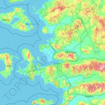
Name: Izmir topographic map, elevation, terrain.
Location: Izmir, Aegean Region, Turkey (37.81523 26.17079 39.38549 28.49308)
Average elevation: 210 m
Minimum elevation: -3 m
Maximum elevation: 2,113 m
Make a donation
Other topographic maps
Click on a map to view its topography, its elevation and its terrain.
Make a donation
Make a donation
Şanlıurfa
An important consideration in domestic architecture is mahremiyat, which could roughly be translated into English as "privacy" or "intimacy" but which carries stronger implications. This concept is especially important when it comes to relations between men and women – outside the extended family,…
Average elevation: 623 m
Gaziantep
The plan introduced several important changes to the city's transportation network. One of the most important was the addition of a rail line to connect Gaziantep to the national rail system. Up to now, Turkish railway construction had ignored Gaziantep (partly because of its mountainous surroundings); a…
Average elevation: 880 m
Make a donation
Gemlik
Gemlik has a hot-summer Mediterranean climate (Köppen climate classification: Csa') with cool and rainy winters, and hot and dry summers. The driest month is July with an average of 22 mm (0.87 in) of rainfall. The wettest month is December with an average of 98 mm (3.9 in) of precipitation. Although a…
Average elevation: 179 m
Make a donation