
Make a donation
Broad Haven topographic map
Click on the map to display elevation.
Make a donation
About this map
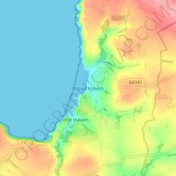
Name: Broad Haven topographic map, elevation, terrain.
Location: Broad Haven, Pembrokeshire, Wales, SA62 3JR, United Kingdom (51.76037 -5.12238 51.80037 -5.08238)
Average elevation: 41 m
Minimum elevation: 0 m
Maximum elevation: 115 m
Make a donation
Other topographic maps
Click on a map to view its topography, its elevation and its terrain.
Milford Haven
United Kingdom > Wales > Pembrokeshire
One of the earliest notable figures from the Milford Haven area is Howell Davis, a pirate born in 1680. He was shot dead in 1719 on the Portuguese island of Príncipe. Other famous residents connected as seafarers include Isaac Davis, a former seaman who was engaged in the fur trade between the Pacific…
Average elevation: 36 m
Make a donation
Make a donation
Make a donation
Preseli Mountains
United Kingdom > Wales > Pembrokeshire > Puncheston
Samuel Lewis's A Topographical Dictionary of Wales published in 1833 said of Maenclochog parish.
Average elevation: 217 m
Make a donation
Make a donation
Make a donation
Caldey Island
United Kingdom > Wales > Pembrokeshire
Caldey Island is about 1.5 miles (2.4 km) long and 1 mile (1.6 km) in width at its widest. It has an area of 538 acres (2.18 km2) and its highest elevation is 197 feet (60 m). The island lies in Carmarthen Bay on the northern side of the Bristol Channel in the county of Pembrokeshire, a little over 2.5 miles…
Average elevation: 5 m
Make a donation
Puncheston
United Kingdom > Wales > Pembrokeshire
A map of 1578 shows the parish as Castle Male, presumably a phonetic spelling of the Welsh name by the English mapmaker. Lewis's Topographical Dictionary of 1844 gives 326 inhabitants (the 1849 edition gives 255) for the parish, which includes the village and a number of outlying residences and farms. Lewis…
Average elevation: 165 m
Make a donation
Make a donation
Milford Haven
United Kingdom > Wales > Pembrokeshire
One of the earliest notable figures from the Milford Haven area is Howell Davis, a pirate born in 1680. He was shot dead in 1719 on the Portuguese island of Príncipe. Other famous residents connected as seafarers include Isaac Davis, a former seaman who was engaged in the fur trade between the Pacific…
Average elevation: 36 m