
Thank you for supporting this site ❤️
Make a donation
Make a donation
Ramsey Island topographic map
Click on the map to display elevation.
Thank you for supporting this site ❤️
Make a donation
Make a donation
About this map
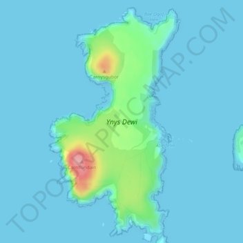
Name: Ramsey Island topographic map, elevation, terrain.
Location: Ramsey Island, St Davids, Pembrokeshire, Wales, United Kingdom (51.85378 -5.35330 51.87915 -5.32967)
Average elevation: 14 m
Minimum elevation: -1 m
Maximum elevation: 130 m
Thank you for supporting this site ❤️
Make a donation
Make a donation
Other topographic maps
Click on a map to view its topography, its elevation and its terrain.
Square and Compass
United Kingdom > Wales > Pembrokeshire > St Davids > Square and Compass
Average elevation: 91 m