
Alpes de Schwyz topographic map
Interactive map
Click on the map to display elevation.
About this map
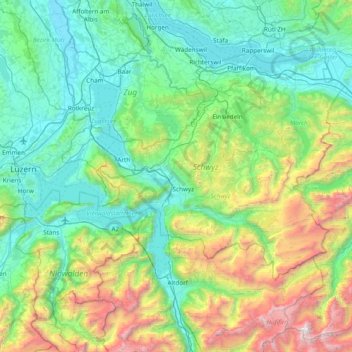
Name: Alpes de Schwyz topographic map, elevation, terrain.
Location: Alpes de Schwyz, Schwyz, Suisse (46.86249 8.35222 47.21653 9.11850)
Average elevation: 1,093 m
Minimum elevation: 380 m
Maximum elevation: 3,554 m
Other topographic maps
Click on a map to view its topography, its elevation and its terrain.
Lac des Quatre Cantons
Lac des Quatre Cantons, Gersau, Schwyz, Suisse
Average elevation: 886 m
Willerzell
Suisse > Schwyz > Einsiedeln > Einsiedeln
Willerzell, Einsiedeln, Schwyz, 8840, Suisse
Average elevation: 958 m
Rickenbach
Suisse > Schwyz > Schwyz > Schwytz
Rickenbach, Schwytz, Schwyz, 6432, Suisse
Average elevation: 751 m
Roetstock
Suisse > Schwyz > Vorderthal
Roetstock, Vorderthal, March, Schwyz, 8857, Suisse
Average elevation: 1,010 m