
Einsiedeln topographic map
Interactive map
Click on the map to display elevation.
About this map
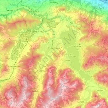
Name: Einsiedeln topographic map, elevation, terrain.
Location: Einsiedeln, Schwyz, 8840, Suisse (47.06327 8.68420 47.17828 8.88661)
Average elevation: 1,023 m
Minimum elevation: 412 m
Maximum elevation: 1,590 m
Other topographic maps
Click on a map to view its topography, its elevation and its terrain.
Willerzell
Suisse > Schwyz > Einsiedeln > Einsiedeln
Willerzell, Einsiedeln, Schwyz, 8840, Suisse
Average elevation: 958 m