
Thank you for supporting this site ❤️
Make a donation
Make a donation
Meslin-l'Évêque topographic map
Click on the map to display elevation.
Thank you for supporting this site ❤️
Make a donation
Make a donation
About this map
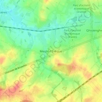
Name: Meslin-l'Évêque topographic map, elevation, terrain.
Location: Meslin-l'Évêque, Ath, Hainaut, Wallonie, 7822, Belgique (50.62858 3.82810 50.66858 3.86810)
Average elevation: 46 m
Minimum elevation: 22 m
Maximum elevation: 79 m
Thank you for supporting this site ❤️
Make a donation
Make a donation
Other topographic maps
Click on a map to view its topography, its elevation and its terrain.
Ath
Belgique > Hainaut > Ath > Ath
Les collines les plus hautes du territoire d'Ath sont le bois du Renard (château d'eau) et la Belle Vue (bois du Roy) à 77,50 mètres. À la limite d'Irchonwelz et d'Ath (haut de la chaussée de Tournai), on enregistre 60 mètres d'altitude, alors que la cuvette d'Ath ne dépasse guère 25 mètres. Mis à…
Average elevation: 44 m