
Make a donation
LaSalle topographic map
Click on the map to display elevation.
Make a donation
About this map
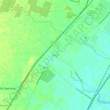
Name: LaSalle topographic map, elevation, terrain.
Location: LaSalle, Monroe County, Michigan, 48145, United States (41.84782 -83.47216 41.88782 -83.43216)
Average elevation: 183 m
Minimum elevation: 175 m
Maximum elevation: 190 m
Make a donation
Other topographic maps
Click on a map to view its topography, its elevation and its terrain.
Monroe
United States > Michigan > Monroe County
According to the United States Census Bureau, the city has a total area of 10.18 square miles (26.37 km2), of which 9.17 square miles (23.75 km2) is land and 1.01 square miles (2.62 km2) (9.92%) is water. Monroe sits at the lowest elevation in state of Michigan, which is the shores of Lake Erie at 571 feet…
Average elevation: 182 m
Frenchtown Charter Township
United States > Michigan > Monroe County
The township is in eastern Monroe County and is bordered to the southeast by Lake Erie. Many of the township's communities are located near the lake. Sterling State Park is located along the southern edge of the township and is the only Michigan state park on Lake Erie. Small pieces of the township are…
Average elevation: 181 m
Make a donation
Make a donation
Monroe
United States > Michigan > Monroe County
Monroe is in eastern Monroe County, with its city limits extending southeast3 miles (5 km) from the downtown to Lake Erie. The average elevation of the city is 594 feet (181 metres), decreasing to 571 feet (174 metres) at Lake Erie, which sits at the lowest elevation in Michigan. The Port of Monroe is the only…
Average elevation: 182 m
Make a donation
Frenchtown Charter Township
United States > Michigan > Monroe County
The township is in eastern Monroe County and is bordered to the southeast by Lake Erie. Many of the township's communities are located near the lake. Sterling State Park is located along the southern edge of the township and is the only Michigan state park on Lake Erie. Small pieces of the township are…
Average elevation: 181 m
Make a donation
River Raisin
United States > Michigan > Monroe County > Raisinville Township > Grape
Average elevation: 192 m