
Chandpur topographic map
Interactive map
Click on the map to display elevation.
About this map
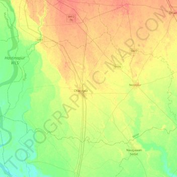
Name: Chandpur topographic map, elevation, terrain.
Location: Chandpur, Bijnor, Uttar Pradesh, Indien (29.01814 78.07591 29.26602 78.51903)
Average elevation: 224 m
Minimum elevation: 204 m
Maximum elevation: 245 m
Other topographic maps
Click on a map to view its topography, its elevation and its terrain.
Faridpur
Faridpur, Distrikt Bareilly, Uttar Pradesh, Indien
Average elevation: 164 m
Palia
Indien > Uttar Pradesh > Palia
Palia, Kheri, Uttar Pradesh, 262902, Indien
Average elevation: 157 m
Chandan Chowky
Indien > Uttar Pradesh > Chandan Chowky
Chandan Chowky, Kheri, Uttar Pradesh, Indien
Average elevation: 159 m
Yamuna
Yamuna, Firozabad, Uttar Pradesh, 282004, Indien
Average elevation: 707 m