
Make a donation
Berkshire County topographic map
Click on the map to display elevation.
Make a donation
Berkshire County
Running north-south through the county are the Hoosac Range of the Berkshire Hills in the eastern part of the county and the Taconic Mountains in the western part of the county. Due to their elevation, the Berkshires attract tourists and summer residents eager to escape the heat of the lowlands.
Make a donation
About this map
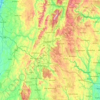
Name: Berkshire County topographic map, elevation, terrain.
Location: Berkshire County, Massachusetts, United States (42.03982 -73.50821 42.74585 -72.94884)
Average elevation: 359 m
Minimum elevation: 2 m
Maximum elevation: 1,061 m
Make a donation
Other topographic maps
Click on a map to view its topography, its elevation and its terrain.
Boston
United States > Massachusetts > Suffolk County > Boston
Boston has an area of 89.63 sq mi (232.1 km2)—48.4 sq mi (125.4 km2) (54%) of land and41.2 sq mi (106.7 km2) (46%) of water. The city's official elevation, as measured at Logan International Airport, is 19 ft (5.8 m) above sea level. The highest point in Boston is Bellevue Hill at 330 ft (100 m) above sea…
Average elevation: 26 m
Make a donation
Make a donation
Make a donation
Make a donation
Berkshire Heights
United States > Massachusetts > Berkshire County > Great Barrington
Average elevation: 243 m
Make a donation
Weymouth Woods
United States > Massachusetts > Norfolk County > Weymouth > South Weymouth > Pine Grove
Average elevation: 49 m
North Sunderland
United States > Massachusetts > Franklin County > Sunderland
Average elevation: 100 m
Make a donation
Bourne Corners
United States > Massachusetts > Barnstable County > Bourne > Buzzards Bay
Average elevation: 9 m
Make a donation
Make a donation
Make a donation
Leonard and Marydee Flynn Cons Area
United States > Massachusetts > Bristol County > Mansfield
Average elevation: 39 m
Make a donation
Make a donation
West Meadow
United States > Massachusetts > Plymouth County > West Bridgewater
Average elevation: 29 m
Make a donation
Mount Everett
United States > Massachusetts > Berkshire County
Mount Everett helps divide the watersheds of the Hudson and Housatonic rivers. Its eastern slopes share a larger escarpment with Mount Race and Bear Mountain plus several related summits. This escarpment rises from an elevation around 700 feet in Sheffield's Housatonic Valley at a mean angle of about 20…
Average elevation: 561 m
Opeechee Heights Beach
United States > Massachusetts > Barnstable County > Barnstable > Centerville
Average elevation: 14 m
Make a donation
Hephzibah Heights
United States > Massachusetts > Berkshire County > Monterey
Average elevation: 457 m
Make a donation
Charles River Village
United States > Massachusetts > Norfolk County > Needham
Average elevation: 49 m
Make a donation
Make a donation
Mount Greylock
United States > Massachusetts > Berkshire County > Adams
Geographically, Mount Greylock is part of an 11-mile-long (18 km) by 4+1⁄2-mile-wide (7 km) island-like range that runs north-south between the Hoosac Range to the east, the Green Mountains to the north, the Berkshires to both the south and east, and the Taconic Mountains to the west with which it is…
Average elevation: 746 m
Make a donation
Framingham Center
United States > Massachusetts > Middlesex County > Framingham
Average elevation: 58 m
Make a donation
Southfield
United States > Massachusetts > Berkshire County > New Marlborough
Average elevation: 405 m
Make a donation
Make a donation
Wachusett Station
United States > Massachusetts > Worcester County > Fitchburg
Average elevation: 229 m
Make a donation
Make a donation
Make a donation
Central (Stanley) Woolen Mill District Park
United States > Massachusetts > Worcester County > Uxbridge
Average elevation: 80 m
Medford Hillside
United States > Massachusetts > Middlesex County > Medford > West Medford
Average elevation: 13 m
Make a donation
Make a donation