
Thank you for supporting this site ❤️
Make a donation
Make a donation
Weymouth Landing topographic map
Click on the map to display elevation.
Thank you for supporting this site ❤️
Make a donation
Make a donation
About this map
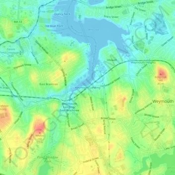
Name: Weymouth Landing topographic map, elevation, terrain.
Average elevation: 21 m
Minimum elevation: -5 m
Maximum elevation: 55 m
Thank you for supporting this site ❤️
Make a donation
Make a donation
Other topographic maps
Click on a map to view its topography, its elevation and its terrain.
Weymouth Woods
United States > Massachusetts > Norfolk County > Weymouth > South Weymouth > Pine Grove
Average elevation: 49 m
02189
United States > Massachusetts > Norfolk County > Weymouth > East Weymouth
Average elevation: 27 m