
Rēzekne topographic map
Interactive map
Click on the map to display elevation.
About this map
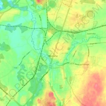
Name: Rēzekne topographic map, elevation, terrain.
Location: Rēzekne, Latgale, Letland (56.47772 27.30306 56.53810 27.37935)
Average elevation: 148 m
Minimum elevation: 119 m
Maximum elevation: 183 m
Other topographic maps
Click on a map to view its topography, its elevation and its terrain.
Indrica
Letland > Latgale > Krāslavas novads
Indrica, Krāslavas novads, Latgale, Letland
Average elevation: 157 m
Ludza
Letland > Latgale > Ludzas novads
Ludza, Ludzas novads, Latgale, Letland
Average elevation: 140 m
Dagda
Letland > Latgale > Krāslavas novads
Dagda, Krāslavas novads, Latgale, Letland
Average elevation: 175 m
Priedaine
Letland > Latgale > Krāslavas novads > Krāslava
Priedaine, Krāslava, Krāslavas novads, Latgale, LV-5601, Letland
Average elevation: 129 m
Vīksna
Letland > Latgale > Balvu novads > Vīksna
Vīksna, Balvu novads, Latgale, Letland
Average elevation: 125 m