
Renfrewshire topographic map
Interactive map
Click on the map to display elevation.
About this map
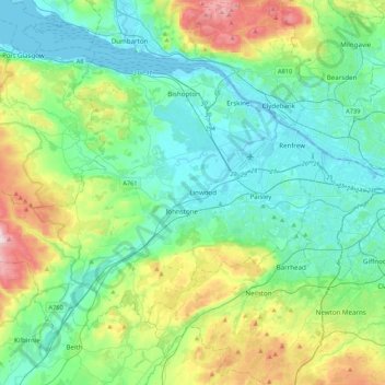
Name: Renfrewshire topographic map, elevation, terrain.
Location: Renfrewshire, Schotland, VK (55.75952 -4.78401 55.93629 -4.35311)
Average elevation: 104 m
Minimum elevation: -5 m
Maximum elevation: 435 m
Other topographic maps
Click on a map to view its topography, its elevation and its terrain.
Old Polmont
VK > Schotland > Old Polmont
Old Polmont, Falkirk, Schotland, FK2 0XZ, VK
Average elevation: 37 m
Greenbraehead
VK > Schotland > Greenbraehead
Greenbraehead, Scottish Borders, Schotland, TD9 9SW, VK
Average elevation: 187 m
Carnoustie
VK > Schotland > Carnoustie
Carnoustie, Angus, Schotland, DD7 6AE, VK
Average elevation: 24 m
Loch Lubnaig
VK > Schotland > Ardchullarie More
Loch Lubnaig, A84, Ardchullarie More, Stirling, Schotland, FK17 8HF, VK
Average elevation: 382 m
Inverasdale
VK > Schotland > Inverasdale
Inverasdale, Highland, Schotland, IV22 2LW, VK
Average elevation: 54 m
Loch Lomond
Loch Lomond, A82, Tom Na Glas, Inverbeg, Argyll and Bute, Schotland, G83 8PD, VK
Average elevation: 240 m
Fort Augustus
VK > Schotland > Fort Augustus
Fort Augustus, Highland, Schotland, PH32 4AY, VK
Average elevation: 115 m